
Welcome!
This past year has been one of meaningful progress and reflection for County Planning. Our work advanced across a multitude of areas—from community planning and zoning initiatives to data-rich resources and mapping—supported by intentional public engagement efforts designed to improve connections, big and small, across Cuyahoga County.
Throughout the year, our team collaborated with residents; elected officials; and public, private, and regional partners to expand mobility options and strengthen the foundation for resilient, welcoming neighborhoods. The accomplishments outlined in this report reflect our ongoing commitment to planning that is inclusive, forward-looking, and grounded in the needs and aspirations of the people and communities we serve.
As we embark on 2026, we also recognize the 100th anniversary of the Euclid v. Ambler decision—the landmark court case that shaped modern zoning and continues to influence how communities grow and evolve today. Our work to advance planning and zoning best practices is far from finished, and we look forward to sharing more exciting outreach and initiatives in the year ahead.
Mary Cierebiej, AICP
Executive Director
The 2025 Annual Report is presented in an interactive format, and our project work is categorized as:
As you review our project work in 2025, we invite you to consider how County Planning can help your community reach its goals this year and beyond.
Transit-Oriented Development
2025 was a productive year for County Planning's Transit-Oriented Development (TOD) Initiative. The TOD Trends Report showed measurable advancement of TOD in Cuyahoga County. Additionally, 30 new TOD projects experienced significant construction, leading to considerable added building value in 2025.
The TOD Navigator, an online mapping tool, was developed to further foster TOD in Cuyahoga County. It shares information about TOD projects, planning and zoning requirements, and infrastructure projects. The Navigator also shows the retail and gross square footage of each development, the number of units, the number of parking spaces, the project completion year, and affordable units.
County Planning hosted a TOD Summit in June for local developers, lenders, and community leaders interested in learning more about TOD. Based on feedback from the Summit, County Planning worked with the Cuyahoga County Department of Development to create a TOD Loan Program to incentivize mixed-use, high-density development along frequent transit lines with fixed-rate gap financing below market rates.
Cuyahoga Greenways
County Planning continues to encourage further development of the trails network in Cuyahoga County for travel and recreation. In conjunction with the Cuyahoga Greenways Partners, in 2025 County Planning began the process of updating the 2019 Cuyahoga Greenways Plan, a network of over 800 miles of on- and off-road trails in Cuyahoga County. This effort will refresh underlying bikeway data, develop standards for including routes, adjust priority routes, and report the progress of trails' development since 2019.
To assist this effort, County Planning developed the Greenways Facility Editor, a mapping tool that allows municipalities and partners to contribute information on existing and future bike facilities. Information from 53 of the County’s 59 communities resulted in 251 edits to the existing network for additions to the network, removals of unfeasible routes, corrections to underlying data, and additional comments and ideas.
Cuyahoga Greenways Partners Facilities Editor
Our Communities: The 2025 Data Book
Offering a look at the people of Cuyahoga County, this edition of Our Communities incorporated statistics from the U.S. Census Bureau and other sources to provide a 2025 snapshot of the people who live in our communities. This is the fifth Data Book in a series and includes information on demographics, the economy, housing, land use, transportation, and health for each of Cuyahoga County's cities, villages, and townships.
A companion interactive map viewer for the Data Book, the Data Book Viewer, allows spatial examination of key data points across municipalities and census tracts. The indicators shown on the map correspond to the sections in the Data Book.
Acres Rezoned via Zoning Code Updates in 2025
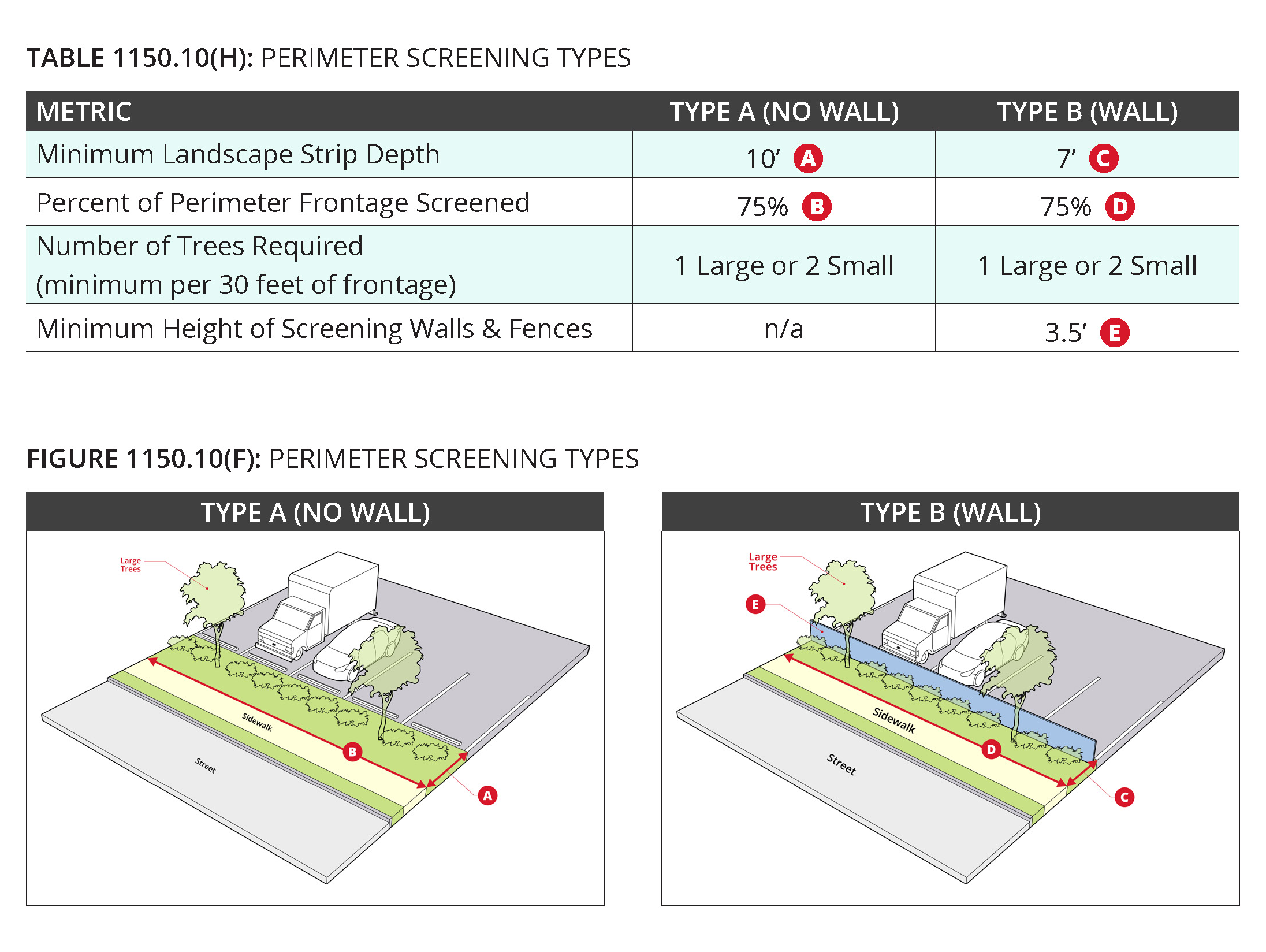
Zoning Code Updates
To advance the vision for transit-oriented development in Cuyahoga County, County Planning worked with three communities in 2025 to update their zoning codes to include TOD-friendly language. Each municipality endeavored to impart their vision through these zoning updates.
- Fairview Park desired regulations to guide development, redevelopment, and promote updates in areas along Lorain Road—making compact, mixed-use, walkable, livable neighborhoods.
- North Olmsted wanted to advance development in the City's mall area through an overlay district, a mapped zone that establishes development standards that are in addition to those of the underlying zoning district. The overlay district provides development regulations for building expansion and new construction to further community goals where the existing zoning does not adequately result in desired development.
- South Euclid recognized the need to modernize the look and appearance of two key shopping neighborhoods in the city to change with the times and grow development opportunities at the historic Cedar Center and the downtown Mayfield-Green shopping districts.
Additionally, County Planning provided best practices and suggested changes to Cleveland Heights' zoning code to allow the construction of accessory dwelling units (ADUs). In East Cleveland, general zoning updates continued in 2025. The 1950s zoning map will be updated and digitized, and both a residential and a commercial overlay district will be established.
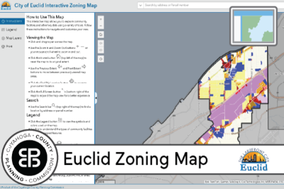
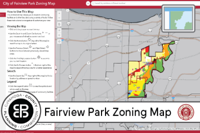
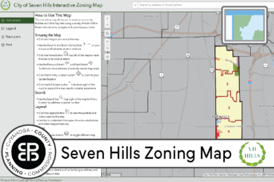
Interactive Zoning Maps
In today’s 24/7 online world, the need to supply information that is accessible at any time of day is key to serving constituents. County Planning has continued to assist municipalities in these efforts and in 2025 created interactive digital zoning maps for three cities, allowing users to seek immediate answers to zoning questions.
Each city's zoning map provides a visual representation of the base zoning districts within the city. Additional information was incorporated based on specific needs:
- Euclid's map includes the downtown overlay district.
- Fairview Park's map includes city wards, community facilities, and a proposed TOD overlay district.
- The Seven Hills map also includes city wards and community facilities.
Number of Interactions on New Zoning Maps
Planning Projects
The focus of County Planning's work is to help Cuyahoga County communities grow and thrive. Toward that end, a variety of planning work was performed in 2025. Four communities undertook a Master Plan process to produce a guide for growth and development over the next decade. One community, Highland Hills, completed the process and adopted a Comprehensive Plan in 2025. The cities of Bedford and Valley View are in the process of developing new Master Plans, and Brooklyn is undergoing an Update of its 2020 Master Plan.
Two communities, Maple Heights and Richmond Heights, pursued the revitalization of important commercial areas in their cities in 2025. Maple Heights worked with County Planning to develop a Redevelopment Plan for the large Southgate Mall area while Richmond Heights concentrated on a Revitalization Plan for the streetscape and business district along the Richmond-Chardon Roads corridor.
County Planning assisted two communities with wayfinding and signage needs in 2025. Cleveland Heights requested a wayfinding and signage plan to assist residents and travelers within the city. Existing signage was reviewed and final recommendations provided guidance on locations, design, materials, content, layout, typologies and other key indicators. Orange Village identified the need for a signage and wayfinding plan based on findings was based on findings from the Orange Community Survey conducted by County Planning in 2024. This new effort began in 2025 and is currently underway. The final plan will offer a cohesive wayfinding signage system based on best practices, and recommendations that will improve system-wide trail connectivity.
Master Plans
Other Plans and Studies
Grant Administration and Support
In 2025, County Planning administered two grant programs on behalf of the Ohio Public Works Commission—the State Capital Improvement Program and the Clean Ohio Greenspace Conservation Program. County Planning also served as administrator and fiscal agent for the Cuyahoga County Healthy Urban Tree Canopy Grant Program.
State Capital Improvement Program
This grant and loan program offers funding for public infrastructure improvements in Cuyahoga County. In 2025, the recommendations for funding included 10 road projects, four stormwater projects, 11 wastewater projects, and three water supply projects.
Clean Ohio Greenspace Conservation Program
This grant program offers funding to projects that preserve open spaces, sensitive ecological areas, and riparian corridors in perpetuity. Two projects were recommended for funding in 2025. The Headwaters Connector Greenway in Solon will create a 100-foot wide, 4.8 mile linear greenway corridor along a former rail corridor. The Headwaters Preserve will permanently protect 35 acres of land along a drainage divide between the Chagrin River and Cuyahoga River watersheds in Orange Village.
Healthy Urban Tree Canopy Grant Program
This grant program offers funding for the growth and preservation of a healthy tree canopy in Cuyahoga County. Eligible projects include tree inventories, tree plans, tree planting, and tree maintenance.

Supporting Community Block Grants
In support of the CDBG program operated through the Cuyahoga County Department Housing and Community Development, County Planning performed required Environmental Review Records (ERRs) analysis in 2025 for projects awarded these federal HUD dollars. The awarded projects were submitted by Cuyahoga County non-entitlement communities for home repair programs, community and senior center improvements, road repair, and playground installations. The ERRs determined potential environmental impacts of the projects to ensure that the property site or surrounding area would not be negatively impacted.
Community Surveys
Surveys are an effective way of gathering ideas, feedback, and opinions from residents on a wide array of topics such as community amenities, recreational options, community services, transportation, housing, trails and greenspace, best use of land, and visions for future development. Surveys are instrumental to the formation of community plans by County Planning.
Community Meetings
Meeting one-on-one with individual community stakeholders and with groups of residents provides valuable input for the plans formulated by County Planning. In 2025, County Planning made a concerted effort to meet residents at informal settings, such as community events and festivals, to gather feedback on community goals and to solicit input on proposed plan recommendations.

Advocacy and Outreach
As a public agency, County Planning strives to inform and educate the planning community and the public about the initiatives undertaken and the plans produced to benefit the growth and development of Cuyahoga County and its communities. This information is communicated through County Planning's website and monthly newsletter. Project plans are available on the website in all stages of plan development, from early stages up to final plan documents, with notifications of surveys offered, survey findings, and public meetings. The monthly newsletter highlights current project work, announces opportunities in the planning process for public input and engagement, and features resources and other materials for informational use and community needs.
Bike-with-a-Mayor Events
County Planning developed and helped to coordinate the Bike-with-a-Mayor Events that were hosted by community mayors in 2025. These events are designed to assist communities in advancing the Cuyahoga Greenways trails network and serve as an avenue for gathering feedback about proposed new routes.

Presentations to Professional Organizations
Well-known for expertise in varied components of planning and design work, County Planning is often asked to present its work to organizations interested in learning more about our projects and efforts. In 2025, County Planning was invited to present information at three national events, three state events, five regional events, and one local event about a variety of topics addressed in recent plans.
- Zoning: TOD zoning, single-family zoning, and mixed-use zoning overlay districts
- Active Transportation: Trail development, Cuyahoga Greenways, and the Lakefront Public Access Plan
- Parks: Park planning and public engagement
- Public Engagement: Community surveys
- Housing: Accessory dwelling units and the federal ROAD Act for affordable housing
Our Vision
Inspiring all of our communities to thrive
Our Mission
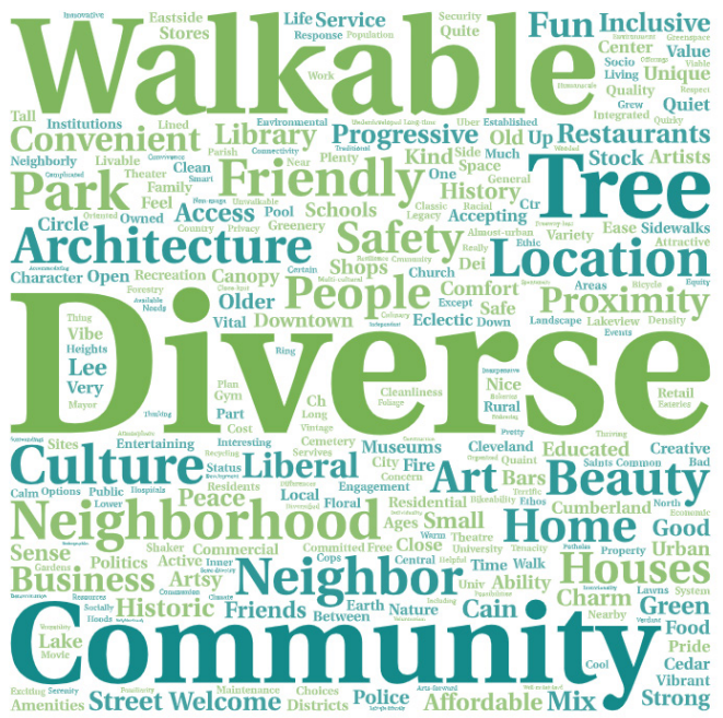
To advance Cuyahoga County’s social, economic, and environmental health through equitable community planning
Our Core Values
Inclusion, Collaboration, Communication, Accountability, Respect, and Excellence


Don't forget to subscribe to our newsletter for timely information and updates!